Colorado's recent push to require wildfire-prone communities to adopt baseline building and property standards comes as an artificial intelligence analysis released this month reveals a substantial portion of the state's housing stock remains exposed to nearby vegetation and other ignition risks.
AI mapping highlights vulnerability across populous counties
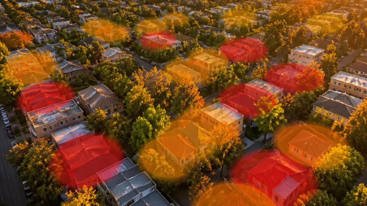
The analysis, conducted by Vexcel, a Colorado-based data firm, used proprietary high-resolution aerial imagery collected by fixed-wing aircraft and applied AI algorithms to identify vegetation and tree canopy in close proximity to structures. The results, shared exclusively with Axios, show striking levels of risk in several densely populated counties.
In Jefferson County, more than 50% of analyzed structures have tree canopy hanging over their roofs, and 78% of the roughly 255,000 structures studied have trees within 5 feet — the most critical zone for reducing ember ignition and direct flame contact.
The study found similar exposure in parts of Denver and contrasted conditions in El Paso County:
| County | Structures analyzed (approx.) | Trees overhanging rooflines | Trees within 5 feet | Vegetation within 30 feet |
|---|---|---|---|---|
| Jefferson | ~255,000 | More than 50% | 78% | — |
| Denver | ~250,000 | 53% | 76% | 94% |
| El Paso | — | 34% | 57% | 77% have no 30-foot buffer |
Why the data matters for new building rules
State regulators have moved to require wildfire-prone local governments to adopt a Wildfire Resiliency Code that mandates defensible space and building practices intended to limit ember-driven ignitions and slow fire spread. Localities may adopt standards that are stricter than the state baseline.
Those codes are partly a response to fast-moving urban-interface fires such as the 2021 Marshall Fire, which demonstrated how quickly wind-driven embers and nearby vegetation can threaten entire neighborhoods.
"I think these codes will save lives, I think they will save property, I think they will save people money," said Crystal Lambert, chair of Colorado's Wildfire Resiliency Code Board.
What the AI approach adds
Vexcel's approach differs from satellite-based studies by relying on aircraft imagery, which offers higher resolution and finer detail of trees, shrubs and built structures. That allows the AI to identify canopy overhangs and vegetation within narrow distances from roofs and other building features.
The firm said its methods enable a parcel-level understanding of where buffers are inadequate — information that could guide local officials and property owners as they prioritize mitigation efforts.
- Homeowners gain clarity on defensible-space priorities: trim branches, remove ladder fuels and create a 5-foot ember-resistant zone near structures.
- Local governments can use parcel-level maps to target outreach, inspections and code enforcement.
- Planners and builders may need to factor setbacks and vegetation management into project designs to meet the new baseline code.
Local differences point to policy and outreach needs
The contrast between counties underscores how readiness varies across the state. For example, a majority of structures in Denver still have tree limbs overhanging rooflines and dense vegetation within typical setback distances — even though the city's overall wildfire ignition risk is lower than in many mountain and foothill communities.
El Paso County fared better on overhanging canopy but still shows substantial numbers of structures lacking a 30-foot vegetation buffer — a common guideline to reduce fire intensity and limit spread.
Officials say the new statewide code sets a minimum; jurisdictions may adopt stricter provisions tailored to local risk. The Vexcel analysis provides a data-driven starting point for officials deciding where to tighten rules and focus mitigation efforts.
Practical next steps for homeowners and localities
While the AI data does not replace on-the-ground assessments, it can help prioritize properties for follow-up inspections and mitigation programs. Homeowners should consult local fire departments and county resources for guidance on creating defensible space and meeting any newly adopted code requirements.
As Colorado implements the Wildfire Resiliency Code, the combination of high-resolution imagery and AI classification offers a scalable way to measure change over time and to evaluate whether required actions are reducing exposure.
State and local officials will need to balance enforcement, incentives and public outreach to translate the map-based findings into smaller risk profiles at the neighborhood and parcel level.
Reporting from Denver.