
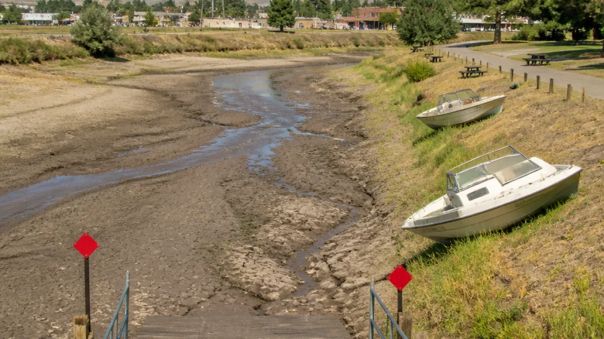
River that supplies La Veta running nearly dry amid one of the driest summers on record
The Cucharas River, which provides the primary water source for the rural town of La Veta and supports ranches and recreation across Huerfano County, has fallen to depths residents say they’ve never seen, as this summer’s drought tightens its grip.
From its headwaters below Trinchera Peak to where it flows past the hamlet of Cuchara and into Bear Lake, the stream has shrunk dramatically. Campground hosts and business owners described unusually low lake levels and creek flows that have already changed daily life and commerce in the region.
What locals are seeing
Visitors who have frequented the area for decades said this spring and summer lacked the usual mountain snowpack that feeds summer flows. At Bear Creek Campground, host Richard Scott Taylor reported lake levels are “more than one-third below average,” leaving shorelines exposed and boat access limited.
"It's never been this shallow," Margaret Hill said, recounting a summer visit to the campground. "I've been coming up here to this area of the woods since I was like 12-years-old and I've never seen it like that ever."
Business owners in tiny Cuchara said they are changing service practices to conserve water. At The Yacht Club restaurant, server Lucy Berumen said staff now only serve water to diners on request to preserve limited supplies.
- Bear Lake: water levels reported more than 33% below average.
- Cuchara community: restaurants limiting water service; visible creekbed exposure.
- Yellow Pine Guest Ranch: irrigation shut off at the headgate as ponds evaporate, harming pastureland.
Economic and recreational impacts
The Yellow Pine Guest Ranch, normally a destination for anglers and horseback riders, has been ordered to close the headgate that supplies water onto pasture and for the ranch’s ponds. Owner Lee Evans said the pond “has gradually dried up” and that bookings are already falling as the landscape browns and fishing opportunities wane.
Lower flows also affect anglers, campers and visitors whose spending supports local eateries and lodgings. The Cucharas corridor is a small but important tourist draw for Huerfano County; reduced recreation could ripple through an economy that depends on seasonal visitors.
Where the water comes from — and why it’s low
The Cucharas begins in the alpine area below Trinchera Peak and collects into Bear Lake before descending to the valley floor. Snowpack and mountain runoff traditionally feed the creek in spring and early summer. This year, locals noted an absence of typical late-winter and spring snow, diminishing runoff when the river normally swells.
| Location | Reported condition |
|---|---|
| Bear Lake | More than one-third below average water level |
| Cuchara village | Creek visibly shallow; businesses restricting water service |
| Yellow Pine Guest Ranch | Headgate closed; pond nearly gone; pastures dry |
Community responses and concerns
Local officials and water managers have directed some ranch and land users to alter water deliveries to conserve remaining supplies. Those restrictions are meant to shore up critical supplies and limit evaporation losses as temperatures remain high.
Residents and business owners said these short-term measures do not erase longer-term anxiety about water security. For families who depend on the creek for domestic use and for livelihoods tied to ranching and tourism, low flows heighten uncertainty about the coming months and the next irrigation season.
Broader context
The Cucharas situation mirrors conditions affecting many small rivers across the West this summer, where low snowpack and sustained warm, dry weather have pushed streams and reservoirs to unusually low levels. Small agricultural communities and rural towns are particularly vulnerable because they have fewer alternative water sources and limited financial resources to adapt.
Practical information for residents and visitors
Visitors planning trips to the Cucharas corridor should check with local campgrounds and businesses before traveling; services such as water availability and recreational activities may be limited. Residents should follow any official water-use directives from local water districts and town authorities to help preserve supplies during peak demand.
State and federal drought-monitoring agencies will continue to track conditions and issue guidance. In the meantime, people in La Veta and surrounding areas are adapting to an unusually dry season that is reshaping both the landscape and local life.
Reporting for this article drew on on-the-ground reporting by KRCC’s Orion Cenkl and interviews with local residents, campground hosts and business owners in Huerfano County.














