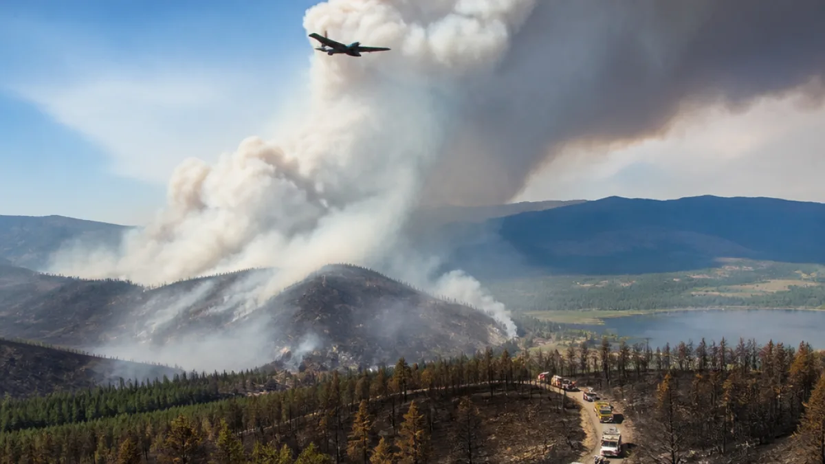
NASA deployed a high‑altitude research aircraft over British Columbia's southern Interior this past weekend to study intense weather produced by the province's largest active blaze. The mission, flown by an ER‑2 — a variant of the Cold War‑era U‑2 — logged multiple passes above the Pear Lake wildfire as crews continue to battle a fire that has blackened almost 1,500 square kilometres.
Flight path and mission
Online flight data shows the ER‑2 took off from Great Falls, Montana, and spent more than six hours in Canadian airspace, including about four hours at roughly 60,000 feet over the Clinton area. The aircraft also swung east over Lake Revelstoke before returning to U.S. airspace. NASA says the flight was part of research into pyrocumulonimbus clouds — intense storm systems created by extreme heat and smoke from large fires.
Fitted with what NASA calls "state‑of‑the‑art infrared wildfire trackers," the ER‑2 is configured to capture thermal and atmospheric measurements at altitudes about twice that of commercial airliners. The aircraft's sensors are intended to map, measure and time the development of fire‑driven storms in real time.
"Smoky and crackling with lightning, these unique storms can create blind spots for aviators above and spark new blazes below," NASA said in a news release.
Why pyrocumulonimbus matter in B.C.
The BC Wildfire Service has confirmed that the Pear Lake blaze has produced pyrocumulonimbus formations. These clouds are among the least understood severe weather events on Earth because they combine wildfire dynamics with atmospheric instability to generate intense local effects.
Key concerns for emergency managers and pilots include:
- Sudden lightning strikes that can ignite new fires downwind.
- Localized heavy downpours or hail that may be patchy and unpredictable.
- Strong updrafts and rotating columns — sometimes described as fire tornadoes — that make fire behaviour erratic and dangerous.
Local impact and practical implications
For communities and crews operating in the southern Interior, better forecasting of pyrocumulonimbus could translate into improved situational awareness and safer evacuation and aviation decisions. Blind spots created by dense smoke and turbulence pose hazards to air tankers and helicopters, while lightning from these storms can rapidly create new spot fires in otherwise stable areas.
While the ER‑2 mission does not directly assist firefighting on the ground, the data it collects can help scientists refine models that predict when and where fire‑driven storms will form. Over time, those models may inform tactical decisions such as when to suspend aerial operations, where to position crews and how to prioritise evacuations.
About the aircraft and the science
The ER‑2 is a high‑altitude research aircraft derived from the U‑2 reconnaissance plane. Its ceiling allows instruments to view the vertical structure of the atmosphere above fire plumes. NASA says measuring and mapping these dangerous storms as they develop "will help scientists forecast them in the future."
| Item | Detail |
|---|---|
| Aircraft | NASA ER‑2 (U‑2 variant) |
| Flight origin | Great Falls, Montana |
| Operational altitude during passes | Approx. 60,000 feet |
| Primary target | Pear Lake wildfire / pyrocumulonimbus clouds |
Researchers emphasise that pyrocumulonimbus are not only meteorological curiosities but also practical hazards in a wildfire season that has intensified across the West Coast in recent years. Better observational data from high‑altitude platforms, satellites and ground stations is central to improving forecasts.
For residents and travellers in the Interior, the immediate takeaway remains unchanged: follow guidance from the BC Wildfire Service and local authorities. Aviation operators are particularly attentive to reports of pyrocumulonimbus, as the combination of smoke, turbulence and lightning can force rapid changes in flight safety decisions.
As the Pear Lake fire continues to burn, collaborations between federal research agencies and provincial wildfire managers highlight the growing role of science in managing complex wildfire behaviour. The ER‑2 mission offers another source of detailed measurements that scientists hope will make such storms less unpredictable in future seasons.