Satellite imagery released this week exposes the scale of damage inflicted on London’s green spaces by weeks of near‑record heat and scant rainfall, with some of the capital’s best‑loved parks now “frazzled” into parched landscapes.
Visible change from space
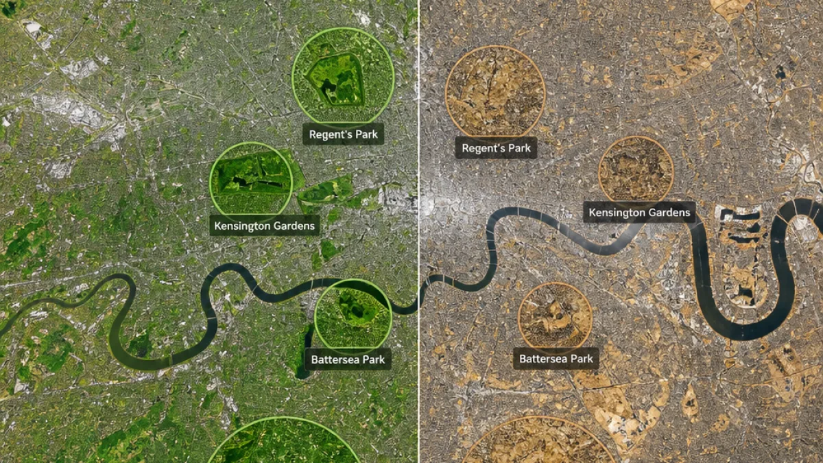
Geospatial analytics firm Map Impact supplied images showing the same areas in March and July, laying bare rapid changes to vegetation across the capital. Victoria Park, long celebrated as the “People’s Park” for east London, is shown in the images as a swathe of straw‑coloured grass where green lawn once dominated. The park covers about 86 hectares and attracts more than nine million visitors a year, according to the material accompanying the imagery.
Royal parks were not spared. Photographs of Hyde Park and Kensington Gardens show a marked loss of green cover around the Serpentine, while images of Richmond Park similarly indicate large areas of stressed vegetation.
What the images reveal
The images were prepared by Map Impact using modified Copernicus Sentinel data. They illustrate the cumulative impact of a spell of unusually high temperatures and almost no rain for weeks — conditions scientists link to the increasing frequency of extreme weather events driven by global warming.
Map Impact scientists say the visual contrast between early spring and mid‑summer is stark. In Victoria Park, the photographs show a dramatic transition from the lush green of March to the dried, pale turf of July. In practical terms, the change threatens recreational use, local biodiversity and the urban cooling benefits parks provide.
Local impact and concerns
Residents and regular park users tell me the scenes on the ground match what the satellites show. People who rely on parks for exercise, respite from the city and community events are already reporting fewer usable areas and a rise in dust‑dry earth where grass has died back.
Urban planners and environmental groups warn that prolonged stress on urban trees and grass will have longer‑term consequences for wildlife, soil health and water retention in public spaces. The loss of green cover also reduces the city’s ability to mitigate heat through shading and evapotranspiration — exactly when vulnerable Londoners need it most.
- Victoria Park: Around 86 hectares; images show extensive browning by July.
- Hyde Park & Kensington Gardens: Notable decline in green cover around the Serpentine.
- Richmond Park: Large areas appear stressed and desiccated in July imagery.
Practical implications for Londoners
Park closures or restrictions are a possibility if grounds become unsafe or repairs are needed. Even where parks remain open, usability is reduced: social events and sports fixtures may be relocated or cancelled, and exposed soil increases dust and erosion risks.
For residents seeking respite from heat, the loss of shaded, green areas will be keenly felt. City authorities and charities frequently advise people to seek cooler indoor spaces, hydrate and check on vulnerable neighbours during extreme heat events — guidance that becomes harder to follow when outdoor cooling options are diminished.
Data at a glance
| Park | Notable points from imagery |
|---|---|
| Victoria Park | Marked change from green (March) to straw‑coloured (July); 86 hectares; ~9m visitors/year |
| Hyde Park & Kensington Gardens | Loss of green cover around the Serpentine; areas appear stressed |
| Richmond Park | Large patches of vegetation show drought stress in July imagery |
The dataset used by Map Impact is sourced from the European Copernicus Sentinel programme, processed to highlight vegetation changes between March and July.
Wider context
Scientists have warned for years that hotter, drier summers are likely to become more common in the UK. The images supply a concrete, public‑facing demonstration of that trend and raise questions about how the capital will manage and protect urban green infrastructure in future.
Local authorities face difficult choices: invest in irrigation and more resilient planting schemes, introduce restrictions on water use, or accept a changing landscape where some grassy areas may be repurposed to be less water dependent. Each option carries costs and trade‑offs for residents and for biodiversity.
Map Impact’s imagery offers a clear moment of reckoning for Londoners and policymakers alike: the city’s parks are not immune to climate stress, and the visual evidence from space underlines the urgency of planning for hotter summers.